
Carte topographique Lake Nakuru
Carte interactive
Cliquez sur la carte pour afficher l’altitude.
À propos de cette carte
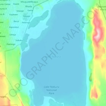
Nom : Carte topographique Lake Nakuru, altitude, relief.
Lieu : Lake Nakuru, Kaloleni, Nakuru, Kenya (-0.40762 36.05632 -0.30774 36.11811)
Altitude moyenne : 1 807 m
Altitude minimum : 1 754 m
Altitude maximum : 2 095 m
Lake Nakuru is one of the Rift Valley soda lakes at an elevation of 1,754 m (5,755 ft) above sea level. It lies to the south of Nakuru, in the rift valley of Kenya and is protected by Lake Nakuru National Park.