
Carte topographique Dún Laoghaire-Rathdown
Carte interactive
Cliquez sur la carte pour afficher l’altitude.
À propos de cette carte
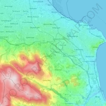
Nom : Carte topographique Dún Laoghaire-Rathdown, altitude, relief.
Lieu : Dún Laoghaire-Rathdown, County Dublin, Leinster, Ireland (53.19873 -6.29937 53.31487 -6.07510)
Altitude moyenne : 139 m
Altitude minimum : -1 m
Altitude maximum : 583 m
Autres cartes topographiques
Cliquez sur une carte pour visualiser sa topographie, son altitude et son relief.
Tallaght
Ireland > County Dublin > Tallaght
Tallaght, South Dublin, County Dublin, Leinster, D24 T99C, Ireland
Altitude moyenne : 121 m
Loughlinstown River, North
Loughlinstown River, North, Loughlinstown, Killiney South ED, Dún Laoghaire-Rathdown, County Dublin, Leinster, D18 KP65, Ireland
Altitude moyenne : 36 m
14
Ireland > County Dublin > Blackrock
14, The Stables, Mount Merrion, Mountmerrion or Callary, Stillorgan-Mount Merrion ED, Blackrock, Dún Laoghaire-Rathdown, County Dublin, Leinster, A94 EK75, Ireland
Altitude moyenne : 48 m
Dún Laoghaire
Dún Laoghaire, Dún Laoghaire-Rathdown, County Dublin, Leinster, A96 T860, Ireland
Altitude moyenne : 21 m
Blackrock
Ireland > County Dublin > Blackrock
Blackrock, Dún Laoghaire-Rathdown, County Dublin, Leinster, A94 RF20, Ireland
Altitude moyenne : 30 m