
Carte topographique Jacobsdal
Carte interactive
Cliquez sur la carte pour afficher l’altitude.
À propos de cette carte
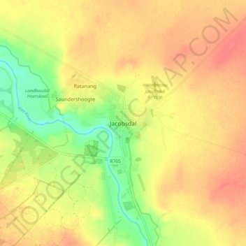
Nom : Carte topographique Jacobsdal, altitude, relief.
Altitude moyenne : 1 147 m
Altitude minimum : 1 116 m
Altitude maximum : 1 166 m
Autres cartes topographiques
Cliquez sur une carte pour visualiser sa topographie, son altitude et son relief.
Koffiefontein
South Africa > Free State > Xhariep District Municipality > Letsemeng Local Municipality
Koffiefontein, Letsemeng Local Municipality, Xhariep District Municipality, Free State, South Africa
Altitude moyenne : 1 203 m
Paardeberg
South Africa > Free State > Xhariep District Municipality > Letsemeng Local Municipality
Paardeberg, Letsemeng Local Municipality, Xhariep District Municipality, Free State, South Africa
Altitude moyenne : 1 168 m
Vanderkloof Dam
South Africa > Free State > Xhariep District Municipality > Letsemeng Local Municipality
Vanderkloof Dam, Letsemeng Ward 1, Letsemeng Local Municipality, Xhariep District Municipality, Free State, South Africa
Altitude moyenne : 1 188 m
Petrusburg
South Africa > Free State > Xhariep District Municipality > Letsemeng Local Municipality
Petrusburg, Letsemeng Local Municipality, Xhariep District Municipality, Free State, South Africa
Altitude moyenne : 1 257 m