
Carte topographique Porto da Cruz
Carte interactive
Cliquez sur la carte pour afficher l’altitude.
À propos de cette carte
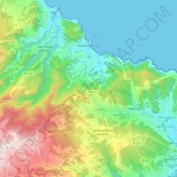
Nom : Carte topographique Porto da Cruz, altitude, relief.
Lieu : Porto da Cruz, Machico, Madeira, Portugal (32.70993 -16.90556 32.78754 -16.78922)
Altitude moyenne : 448 m
Altitude minimum : -2 m
Altitude maximum : 1 409 m
The northern parish is enveloped by the mountains of Paul da Serra: Pico da Suna (1040 metres), Pico do Larano (765 metres) and Pico da Maiata (766 metres) are the highest points in the parish. Even along the coast, Penha de Águia (a mountainous escarpment 580 metres in altitude) is difficult to climb; the area, Penha da Águia, means mountain of the eagles, giving the impression that only the birds settle these lands.
Autres cartes topographiques
Cliquez sur une carte pour visualiser sa topographie, son altitude et son relief.