
Carte topographique Slaley
Carte interactive
Cliquez sur la carte pour afficher l’altitude.
À propos de cette carte
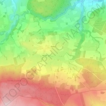
Nom : Carte topographique Slaley, altitude, relief.
Lieu : Slaley, Northumberland, North of Tyne, England, United Kingdom (54.88025 -2.10625 54.94252 -2.00054)
Altitude moyenne : 210 m
Altitude minimum : 58 m
Altitude maximum : 383 m
Autres cartes topographiques
Cliquez sur une carte pour visualiser sa topographie, son altitude et son relief.
Holy Island of Lindisfarne
United Kingdom > England > Northumberland > Holy Island
Holy Island of Lindisfarne, Holy Island, Northumberland, North East England, England, United Kingdom
Altitude moyenne : 1 m