
Carte topographique Aurillac
Carte interactive
Cliquez sur la carte pour afficher l’altitude.
À propos de cette carte
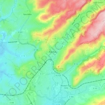
Nom : Carte topographique Aurillac, altitude, relief.
Altitude moyenne : 668 m
Altitude minimum : 569 m
Altitude maximum : 876 m
Influenced by its altitude, Aurillac features an oceanic climate (Cfb), closely bordering on a warm-summer humid continental climate (Dfb) under the Köppen system. In spite of this, the city enjoys more than 2,100 hours of sunshine per year on average, but also a high amount of precipitations per year on average. The record low temperature was −24.5 °C (−12 °F) on 9 January 1985 and the record high was 38.0 °C (100 °F) on 30 July 1983.
Autres cartes topographiques
Cliquez sur une carte pour visualiser sa topographie, son altitude et son relief.
Mandailles-Saint-Julien
France > Auvergne-Rhône-Alpes > Cantal > Mandailles-Saint-Julien
Mandailles-Saint-Julien, Aurillac, Cantal, Auvergne-Rhône-Alpes, Metropolitan France, 15590, France
Altitude moyenne : 1 243 m
Saint-Paul-de-Salers
France > Auvergne-Rhône-Alpes > Cantal > Saint-Paul-de-Salers
Saint-Paul-de-Salers, Mauriac, Cantal, Auvergne-Rhône-Alpes, Metropolitan France, 15140, France
Altitude moyenne : 965 m