
Carte topographique San Jorge
Carte interactive
Cliquez sur la carte pour afficher l’altitude.
À propos de cette carte
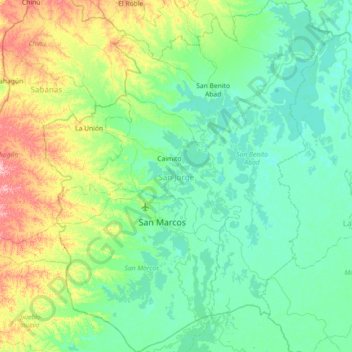
Nom : Carte topographique San Jorge, altitude, relief.
Lieu : San Jorge, Sucre, RAP Caribe, Colombia (8.39830 -75.37397 9.10911 -74.77568)
Altitude moyenne : 38 m
Altitude minimum : 7 m
Altitude maximum : 157 m
Autres cartes topographiques
Cliquez sur une carte pour visualiser sa topographie, son altitude et son relief.
La Soledad
Colombia > Sucre > Los Palmitos
La Soledad, Los Palmitos, Sabanas, Sucre, RAP Caribe, Colombia
Altitude moyenne : 195 m
Pajonal
Colombia > Sucre > San Onofre > Pajonal
Pajonal, San Onofre, Morrosquillo, Sucre, Colombia
Altitude moyenne : 76 m