
Carte topographique Santa María de la Alameda
Carte interactive
Cliquez sur la carte pour afficher l’altitude.
À propos de cette carte
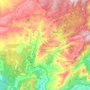
Nom : Carte topographique Santa María de la Alameda, altitude, relief.
Altitude moyenne : 1 339 m
Altitude minimum : 872 m
Altitude maximum : 1 783 m
Originally a group of cattle-raising hamlets, the municipality comprises different settlements: Las Herreras, El Pimpollar, La Hoya, Navalespino, La Paradilla, Robledondo, Santa María de la Alameda and Santa María Estación. In time, the nucleus of "Santa María Estación", developed around the railway station, has grown to become the most populated settlement. The capital of the municipality (the namesake "Santa María de la Alameda") is located at an elevation of 1,409 metres. The municipality covers an area of 74.41 km2, including the exclave of Dehesa de la Cepeda, a mostly pasture area geographically located between the provinces of Ávila and Segovia in the autonomous community of Castile and León.
Autres cartes topographiques
Cliquez sur une carte pour visualiser sa topographie, son altitude et son relief.
Navalagamella
Spain > Community of Madrid > Sierra Oeste
Navalagamella, Sierra Oeste, Community of Madrid, 28212, Spain
Altitude moyenne : 718 m