
Carte topographique Malindi
Carte interactive
Cliquez sur la carte pour afficher l’altitude.
À propos de cette carte
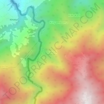
Nom : Carte topographique Malindi, altitude, relief.
Lieu : Malindi, Sindila, Bundibugyo, Western Region, Uganda (0.52607 29.96488 0.56607 30.00488)
Altitude moyenne : 2 227 m
Altitude minimum : 1 478 m
Altitude maximum : 2 979 m
Autres cartes topographiques
Cliquez sur une carte pour visualiser sa topographie, son altitude et son relief.
Bundibugyo
Bundibugyo, Bundibugyo Town Council, Bundibugyo, Western Region, Uganda
Altitude moyenne : 994 m
Rwenzori Mountains
Uganda > Bundibugyo > Sindila
Rwenzori Mountains, Sindila, Bundibugyo, Western Region, Uganda
Altitude moyenne : 1 570 m
Mount Gessi
Uganda > Bundibugyo > Sindila
Mount Gessi, Sindila, Bundibugyo, Western Region, Uganda
Altitude moyenne : 4 127 m