
Faire un don
Équipez-vous pour votre prochaine aventure :
En tant que Partenaire Amazon, ce site perçoit une commission sur les achats éligibles sans surcoût pour vous.
Carte topographique Kennetcook
Cliquez sur la carte pour afficher l’altitude.
Faire un don
Équipez-vous pour votre prochaine aventure :
En tant que Partenaire Amazon, ce site perçoit une commission sur les achats éligibles sans surcoût pour vous.
À propos de cette carte
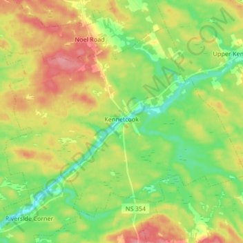
Nom : Carte topographique Kennetcook, altitude, relief.
Altitude moyenne : 59 m
Altitude minimum : 21 m
Altitude maximum : 108 m
Faire un don
Équipez-vous pour votre prochaine aventure :
En tant que Partenaire Amazon, ce site perçoit une commission sur les achats éligibles sans surcoût pour vous.
Autres cartes topographiques
Cliquez sur une carte pour visualiser sa topographie, son altitude et son relief.
Nova Scotia peninsula
Canada > Nova Scotia > Hants County > Upper Rawdon
The Cobequid Mountains contain the highest elevation points on the peninsula. This low, heavily eroded part of the Appalachian Mountains, along with the Pictou-Antigonish Highlands, comprises a highland across the northern portion of the peninsula with average elevations between 250–300 metres. It was…
Altitude moyenne : 118 m
Faire un don
Équipez-vous pour votre prochaine aventure :
En tant que Partenaire Amazon, ce site perçoit une commission sur les achats éligibles sans surcoût pour vous.