
Faire un don
Équipez-vous pour votre prochaine aventure :
En tant que Partenaire Amazon, ce site perçoit une commission sur les achats éligibles sans surcoût pour vous.
Carte topographique Sonneberg
Cliquez sur la carte pour afficher l’altitude.
Faire un don
Équipez-vous pour votre prochaine aventure :
En tant que Partenaire Amazon, ce site perçoit une commission sur les achats éligibles sans surcoût pour vous.
Sonneberg
"The Sonneberg Castle was also called Sonneberg Castle or the Haus zu Sonneberg in old documents. In 480 Süne or Süno, Duke of Franconia, built this castle because of the Thuringian incursions ..." so it says on page 64 in the topography of the Duke of Saxe-Meiningen's share in the Duchy of Coburg from the year 1781. This not uncritical representation is based on the history of the Franks by Abbot Johannes Trithemius from 1514.
Faire un don
Équipez-vous pour votre prochaine aventure :
En tant que Partenaire Amazon, ce site perçoit une commission sur les achats éligibles sans surcoût pour vous.
À propos de cette carte
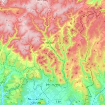
Nom : Carte topographique Sonneberg, altitude, relief.
Lieu : Sonneberg, Landkreis Sonneberg, Thuringia, 96515, Germany (50.32086 11.11405 50.50751 11.28479)
Altitude moyenne : 586 m
Altitude minimum : 327 m
Altitude maximum : 866 m
Faire un don
Équipez-vous pour votre prochaine aventure :
En tant que Partenaire Amazon, ce site perçoit une commission sur les achats éligibles sans surcoût pour vous.