
Carte topographique Torreón
Carte interactive
Cliquez sur la carte pour afficher l’altitude.
À propos de cette carte
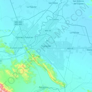
Nom : Carte topographique Torreón, altitude, relief.
Lieu : Torreón, Coahuila, 27289, Mexico (25.38270 -103.57051 25.70270 -103.25051)
Altitude moyenne : 1 166 m
Altitude minimum : 1 108 m
Altitude maximum : 2 151 m
Torreón is near the southwest border of the state of Coahuila, within the Laguna region of the state. The border is delineated by the Nazas River that separates it from Gómez Palacio, Durango. The municipality covers 1,947.7 km2 (752.0 sq mi), including much of the rural area south of the city. The city's elevation is 1,120 m (3,670 ft), which is low for the Mexican interior. The terrain where the urban area is spread is generally flat, with somewhat prominent relief formations (up to 1,600 m (5,249 ft) south and southwest of the city, thus visible at well-nigh any given point in the city. Higher mountains, over 3,000 m (9,843 ft), are on the southern, mostly uninhabited section of the Municipality, the most prominent being El Picacho.