
Carte topographique Reefton
Carte interactive
Cliquez sur la carte pour afficher l’altitude.
À propos de cette carte
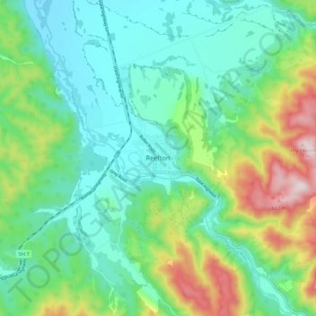
Nom : Carte topographique Reefton, altitude, relief.
Lieu : Reefton, Buller District, West Coast, 7830, New Zealand (-42.15594 171.82346 -42.07594 171.90346)
Altitude moyenne : 310 m
Altitude minimum : 156 m
Altitude maximum : 713 m
Located in the Inangahua Valley at an altitude of 194m, Reefton falls under the Köppen-Geiger climate classification of Cfb (Oceanic). At an average temperature of 15.9 °C, February is the warmest month. July is the coldest month, at 6.8 °C. Reefton's average annual temperature is 11.4 °C. On average, snowfall occurs on 1.4 days annually, and an average of 22.1 days per year will exceed 26.7 °C (80 °F). During an average winter, Reefton can expect to see 47 days of frost.
Autres cartes topographiques
Cliquez sur une carte pour visualiser sa topographie, son altitude et son relief.
Mount Baldy
New Zealand > West Coast > Buller District
Mount Baldy, Buller District, West Coast, New Zealand
Altitude moyenne : 1 059 m
Westport
New Zealand > West Coast > Buller District > Westport
Westport, Buller District, West Coast, 7825, New Zealand
Altitude moyenne : 13 m