
Faire un don
Équipez-vous pour votre prochaine aventure :
En tant que Partenaire Amazon, ce site perçoit une commission sur les achats éligibles sans surcoût pour vous.
Carte topographique Daly City
Cliquez sur la carte pour afficher l’altitude.
Faire un don
Équipez-vous pour votre prochaine aventure :
En tant que Partenaire Amazon, ce site perçoit une commission sur les achats éligibles sans surcoût pour vous.
Daly City
Several golf courses are located within or straddle the border with San Francisco. The Olympic Club has hosted the USGA U.S. Open five times, most recently in 2012, and will host both the 2028 PGA Championship and the 2032 Ryder Cup. The private San Francisco Golf Club and Lake Merced Golf Club have part or all of their course in Daly City. The Golden Gate National Recreation Area includes the city's Thornton Beach. The topography of this area (due to the San Andreas fault) is conducive to paragliding and hang gliding.
Faire un don
Équipez-vous pour votre prochaine aventure :
En tant que Partenaire Amazon, ce site perçoit une commission sur les achats éligibles sans surcoût pour vous.
À propos de cette carte
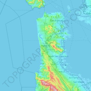
Nom : Carte topographique Daly City, altitude, relief.
Altitude moyenne : 32 m
Altitude minimum : -6 m
Altitude maximum : 567 m
Faire un don
Équipez-vous pour votre prochaine aventure :
En tant que Partenaire Amazon, ce site perçoit une commission sur les achats éligibles sans surcoût pour vous.
Autres cartes topographiques
Cliquez sur une carte pour visualiser sa topographie, son altitude et son relief.
Bayshore Heights Park
United States > California > San Mateo County > Daly City
Altitude moyenne : 84 m