
Carte topographique Wilmington
Carte interactive
Cliquez sur la carte pour afficher l’altitude.
À propos de cette carte
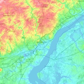
Nom : Carte topographique Wilmington, altitude, relief.
Altitude moyenne : 43 m
Altitude minimum : -5 m
Altitude maximum : 170 m
On the western side of Market Street, the Piedmont topography is rocky and hilly, rising to a point that marks the watershed between the Brandywine River and the Christina River. This watershed line runs along Delaware Avenue westward from 10th Street and Market Street.
Autres cartes topographiques
Cliquez sur une carte pour visualiser sa topographie, son altitude et son relief.
Landlith
United States > Delaware > New Castle County > Wilmington
Landlith, Wilmington, New Castle County, Delaware, 19802, United States
Altitude moyenne : 14 m
Rodney Square
United States > Delaware > New Castle County > Wilmington
Rodney Square, Rodney Square Historic District, Wilmington, New Castle County, Delaware, United States
Altitude moyenne : 20 m
Wawaset Park
United States > Delaware > New Castle County > Wilmington
Wawaset Park, Wilmington, New Castle County, Delaware, 19806, United States
Altitude moyenne : 48 m