
Faire un don
Équipez-vous pour votre prochaine aventure :
En tant que Partenaire Amazon, ce site perçoit une commission sur les achats éligibles sans surcoût pour vous.
Carte topographique Schüttorf
Cliquez sur la carte pour afficher l’altitude.
Faire un don
Équipez-vous pour votre prochaine aventure :
En tant que Partenaire Amazon, ce site perçoit une commission sur les achats éligibles sans surcoût pour vous.
Schüttorf
The town of Schüttorf lies mainly on valley sand plates which are crossed by the Vechte Lowland, which is almost flush with them along this stretch. The lowland lies roughly 30 m above sea level and is from 200 to 500 m wide. Bordering its edges are river terraces with a height of roughly 35 m above sea level. Owing to the slight difference in elevation even within the river valley, the middle Vechte meandered in the past, leading to the formation of many backwaters. Since then, however, the river has been straightened and is kept at Schüttorf level.
Faire un don
Équipez-vous pour votre prochaine aventure :
En tant que Partenaire Amazon, ce site perçoit une commission sur les achats éligibles sans surcoût pour vous.
À propos de cette carte
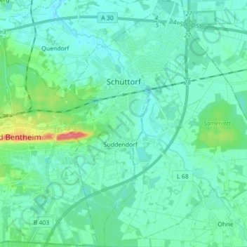
Nom : Carte topographique Schüttorf, altitude, relief.
Altitude moyenne : 39 m
Altitude minimum : 28 m
Altitude maximum : 89 m
Faire un don
Équipez-vous pour votre prochaine aventure :
En tant que Partenaire Amazon, ce site perçoit une commission sur les achats éligibles sans surcoût pour vous.
Autres cartes topographiques
Cliquez sur une carte pour visualiser sa topographie, son altitude et son relief.
Hagelshoek
Germany > Lower Saxony > Landkreis Grafschaft Bentheim > Bad Bentheim > Gildehaus
Altitude moyenne : 48 m