Carte topographique Kozhikode
Carte interactive
Cliquez sur la carte pour afficher l’altitude.
À propos de cette carte
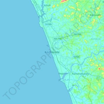
Nom : Carte topographique Kozhikode, altitude, relief.
Lieu : Kozhikode, Kozhikode District, Kerala, 673001, India (11.08506 75.61547 11.40506 75.93547)
Altitude moyenne : 14 m
Altitude minimum : -2 m
Altitude maximum : 272 m
Autres cartes topographiques
Cliquez sur une carte pour visualiser sa topographie, son altitude et son relief.
Thadambattuthazham
Thadambattuthazham, Kozhikode, Kozhikode District, Kerala, 673010, India
Altitude moyenne : 17 m
Mananchira
India > Kerala > Kozhikode > Kozhikode
Mananchira, Palayam, Kozhikode, Kozhikode district, Kerala, India
Altitude moyenne : 12 m
Parambil Bazar
Parambil Bazar, Kozhikode, Kozhikode district, Kerala, 673012, India
Altitude moyenne : 25 m
Pantheerankave
Pantheerankave, Kozhikode, Kozhikode district, Kerala, 673027, India
Altitude moyenne : 21 m
Methottu thazham
India > Kerala > Kozhikode > Kozhikode
Methottu thazham, Kozhikode, Kozhikode district, Kerala, 673016, India
Altitude moyenne : 24 m
Sarovaram Bio Park
India > Kerala > Kozhikode > Erenjippalam
Sarovaram Bio Park, Mini Byepass Road, Jawahar Nagar, Erenjippalam, Kozhikode, Kozhikode district, Kerala, 673004, India
Altitude moyenne : 14 m
Kunnamangalam
Kunnamangalam, Kozhikode, Kozhikode District, Kerala, 673571, India
Altitude moyenne : 35 m