
Carte topographique Château-Renault
Carte interactive
Cliquez sur la carte pour afficher l’altitude.
À propos de cette carte
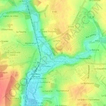
Nom : Carte topographique Château-Renault, altitude, relief.
Altitude moyenne : 112 m
Altitude minimum : 83 m
Altitude maximum : 141 m
Château-Renault is located on the Far-West of the Gâtine Tourangelle plateau, next to the Loir-et-Cher department and at the confluence of two rivers. The Gault and the Brenne. Its Elevation vary between 90 meters and 140 meters on the plateau. The area of the commune is 3.51 square kilometre.