
Carte topographique Lake Baringo
Carte interactive
Cliquez sur la carte pour afficher l’altitude.
Lake Baringo
Lake Baringo is, after Lake Turkana, the most northern of the Kenyan Rift Valley lakes, with a surface area of 130 square kilometres (50 sq mi) and an elevation of 970 metres (3,180 ft). The lake is fed by several rivers: the Molo, Perkerra and Ol Arabel. It has no obvious outlet; the waters are assumed to seep through lake sediments into the faulted volcanic bedrock. It is one of the two freshwater lakes in the Rift Valley in Kenya, the other being Lake Naivasha.
À propos de cette carte
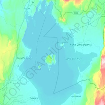
Nom : Carte topographique Lake Baringo, altitude, relief.
Lieu : Lake Baringo, Marigat, Baringo, Rift Valley, Kenya (0.50837 36.01434 0.72866 36.17328)
Altitude moyenne : 1 053 m
Altitude minimum : 964 m
Altitude maximum : 1 635 m
Autres cartes topographiques
Cliquez sur une carte pour visualiser sa topographie, son altitude et son relief.