
Carte topographique Dimitsana
Carte interactive
Cliquez sur la carte pour afficher l’altitude.
À propos de cette carte
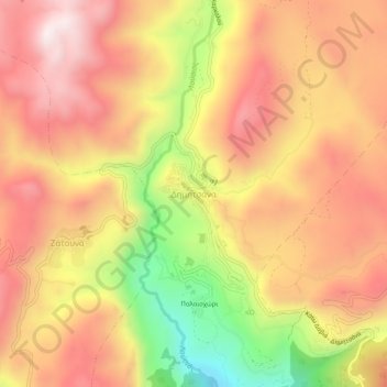
Nom : Carte topographique Dimitsana, altitude, relief.
Altitude moyenne : 1 025 m
Altitude minimum : 553 m
Altitude maximum : 1 335 m
Dimitsana is built on a mountain slope at an elevation of 950 meters. From its southern side a marvelous view of Megalopolis plain and Taygetus is provided. Dimitsana is located 53 km east of Pyrgos, 31 km northwest of Tripoli, 23 km northwest of Megalopoli and 17 km northeast of Andritsaina. The village has a school, a historical library, several churches, a post office, an open-air water-power museum, an open amphitheater, hotels and a square.