
Carte topographique Sandy Lake
Cliquez sur la carte pour afficher l’altitude.
À propos de cette carte
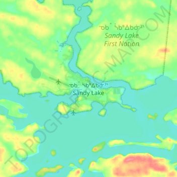
Nom : Carte topographique Sandy Lake, altitude, relief.
Altitude moyenne : 284 m
Altitude minimum : 266 m
Altitude maximum : 328 m
Autres cartes topographiques
Cliquez sur une carte pour visualiser sa topographie, son altitude et son relief.
Lac Seul
Canada > Ontario > Kenora District
Lac Seul is a large, crescent shaped reservoir in Kenora District, northwestern Ontario, Canada. It is approximately 241 km (150 mi) long. It has a maximum (regulated) depth of 47.2 m, with a surface elevation of 357 m above sea level. Its level is raised in the summer and then drawn down in the winter months…
Altitude moyenne : 388 m
Gibi Lake
Canada > Ontario > Kenora District > Sioux Narrows-Nestor Falls Township
Altitude moyenne : 373 m
Nungesser Lake
Canada > Ontario > Kenora District > Unorganized Kenora District
Altitude moyenne : 412 m
Slate Islands
Canada > Ontario > Kenora District > Unorganized Kenora District
Altitude moyenne : 322 m
Loveland Lake
Canada > Ontario > Kenora District > Unorganized Kenora District
Altitude moyenne : 426 m
Galbraith Lake
Canada > Ontario > Kenora District > Unorganized Kenora District
Altitude moyenne : 455 m
Sunlight Lake
Canada > Ontario > Kenora District > Unorganized Kenora District
Altitude moyenne : 374 m
Banana Island
Canada > Ontario > Kenora District > Unorganized Kenora District
Altitude moyenne : 359 m
Ghost Island
Canada > Ontario > Kenora District > Unorganized Kenora District
Altitude moyenne : 401 m
Forbes Lake
Canada > Ontario > Kenora District > Sioux Narrows-Nestor Falls Township
Altitude moyenne : 373 m