
Carte topographique Devin
Carte interactive
Cliquez sur la carte pour afficher l’altitude.
À propos de cette carte
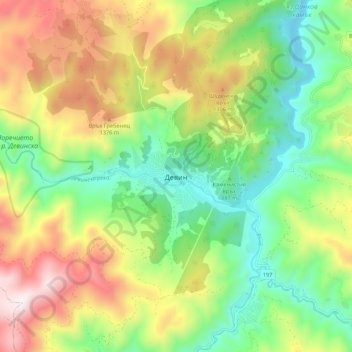
Nom : Carte topographique Devin, altitude, relief.
Lieu : Devin, Smolyan, 4800, Bulgaria (41.70336 24.35846 41.78336 24.43846)
Altitude moyenne : 1 051 m
Altitude minimum : 637 m
Altitude maximum : 1 676 m
The Devinska river runs through it and numerous other brooks and rivers (namely Krichim, Muglenska and Trigradska) are found nearby, all tributaries of the Vacha river. The altitude is uneven owing to the mountainous location, ranging from 684 m to around 800 m above sea level.
Autres cartes topographiques
Cliquez sur une carte pour visualiser sa topographie, son altitude et son relief.
Polkovnik Serafimovo
Bulgaria > Smolyan > Polkovnik Serafimovo
Polkovnik Serafimovo, Smolian, Smolyan, 4702, Bulgaria
Altitude moyenne : 1 019 m
Rhodope Mountains
Rhodope Mountains, Smolyan, Smolian, Smolyan, 4700, Bulgaria
Altitude moyenne : 1 979 m