
Faire un don
Équipez-vous pour votre prochaine aventure :
En tant que Partenaire Amazon, ce site perçoit une commission sur les achats éligibles sans surcoût pour vous.
Carte topographique Dawlish
Cliquez sur la carte pour afficher l’altitude.
Faire un don
Équipez-vous pour votre prochaine aventure :
En tant que Partenaire Amazon, ce site perçoit une commission sur les achats éligibles sans surcoût pour vous.
Dawlish
Little of note happened at Dawlish until the end of the 18th century, when seaside locations on the south coast started to become popular with the wealthy, mainly caused by George III making Weymouth in Dorset his summer holiday residence from 1789. In May 1795, the antiquarian and topographer John Swete spent some time in Dawlish and reported that although not long ago it had been no more than a fishing village, and the best lodging house would not cost more than half a guinea per week, it was now so fashionable that "in the height of the season, not a house of the least consequence is to be hired for less than two guineas a week, and many of them rise to so high a sum as four or five."
Faire un don
Équipez-vous pour votre prochaine aventure :
En tant que Partenaire Amazon, ce site perçoit une commission sur les achats éligibles sans surcoût pour vous.
À propos de cette carte
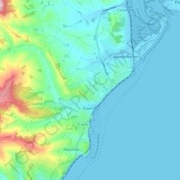
Nom : Carte topographique Dawlish, altitude, relief.
Lieu : Dawlish, Teignbridge, Devon, England, United Kingdom (50.55513 -3.52790 50.61777 -3.42288)
Altitude moyenne : 44 m
Altitude minimum : -1 m
Altitude maximum : 248 m
Faire un don
Équipez-vous pour votre prochaine aventure :
En tant que Partenaire Amazon, ce site perçoit une commission sur les achats éligibles sans surcoût pour vous.