
Carte topographique Bredasdorp
Carte interactive
Cliquez sur la carte pour afficher l’altitude.
À propos de cette carte
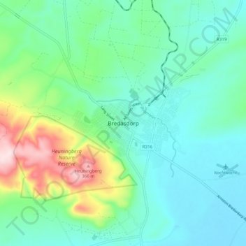
Nom : Carte topographique Bredasdorp, altitude, relief.
Altitude moyenne : 104 m
Altitude minimum : 17 m
Altitude maximum : 384 m
Bredasdorp is situated at an elevation of between 40 and 120 metres (130 and 390 ft) on the slopes of the Heuningberg (Afrikaans for "Honey Mountain"). There is no significant watercourse flowing through the town, although the Kars Rivier flows past a few kilometres to the east.
Autres cartes topographiques
Cliquez sur une carte pour visualiser sa topographie, son altitude et son relief.
Arniston
South Africa > Western Cape > Overberg District Municipality > Cape Agulhas Local Municipality
Arniston, Cape Agulhas Local Municipality, Overberg District Municipality, Western Cape, South Africa
Altitude moyenne : 13 m
Struisbaai
South Africa > Western Cape > Overberg District Municipality > Cape Agulhas Local Municipality > Molshoop
Struisbaai, Cape Agulhas Ward 5, Molshoop, Cape Agulhas Local Municipality, Overberg District Municipality, Western Cape, 7285, South Africa
Altitude moyenne : 27 m
Bredasdorp
South Africa > Western Cape > Overberg District Municipality > Cape Agulhas Local Municipality
Bredasdorp, Cape Agulhas Local Municipality, Overberg District Municipality, Western Cape, 7280, South Africa
Altitude moyenne : 101 m
Skipskop
South Africa > Western Cape > Overberg District Municipality > Cape Agulhas Local Municipality
Skipskop, Cape Agulhas Ward 4, Cape Agulhas Local Municipality, Overberg District Municipality, Western Cape, South Africa
Altitude moyenne : 10 m
De Hoop Nature Reserve
South Africa > Western Cape > Overberg District Municipality > Cape Agulhas Local Municipality
De Hoop Nature Reserve, Cape Agulhas Ward 4, Cape Agulhas Local Municipality, Overberg District Municipality, Western Cape, 7280, South Africa
Altitude moyenne : 63 m
De Mond Nature Reserve
South Africa > Western Cape > Overberg District Municipality > Cape Agulhas Local Municipality
De Mond Nature Reserve, Gravel Road, Cape Agulhas Ward 6, Cape Agulhas Local Municipality, Overberg District Municipality, Western Cape, South Africa
Altitude moyenne : 5 m