
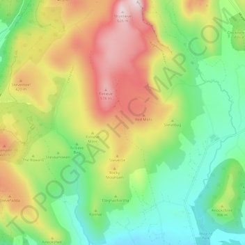
Carte topographique Mourne Mountains West
Carte interactive
Cliquez sur la carte pour afficher l’altitude.
À propos de cette carte
Nom : Carte topographique Mourne Mountains West, altitude, relief.
Altitude moyenne : 272 m
Altitude minimum : 30 m
Altitude maximum : 633 m
Autres cartes topographiques
Cliquez sur une carte pour visualiser sa topographie, son altitude et son relief.
Kilkeel
United Kingdom > Northern Ireland > County Down
Kilkeel, County Down, Ulster, Northern Ireland, BT34 4BH, United Kingdom
Altitude moyenne : 35 m
Belfast
United Kingdom > Northern Ireland > County Antrim > Belfast
Belfast, County Antrim, Ulster, Northern Ireland, BT1 5GS, United Kingdom
Altitude moyenne : 87 m
Lisburn
United Kingdom > Northern Ireland > County Antrim > Lisburn
Lisburn, County Antrim, Northern Ireland, BT28 1BJ, United Kingdom
Altitude moyenne : 92 m
Edenderry
United Kingdom > Northern Ireland > Edenderry
Edenderry, County Down, Northern Ireland, BT8 8LQ, United Kingdom
Altitude moyenne : 39 m
Northern Ireland
United Kingdom > Northern Ireland
Northern Ireland, United Kingdom
Altitude moyenne : 83 m
Feigh Mountain
United Kingdom > Northern Ireland > Dunseverick
Feigh Mountain, Dunseverick, County Antrim, Northern Ireland, United Kingdom
Altitude moyenne : 35 m
Townparks of Strabane
United Kingdom > Northern Ireland > Strabane
Townparks of Strabane, Strabane, County Tyrone, Northern Ireland, United Kingdom
Altitude moyenne : 55 m
Slieve Gullion
United Kingdom > Northern Ireland
Slieve Gullion, County Armagh, Northern Ireland, BT358SY, United Kingdom
Altitude moyenne : 330 m
Lisdrumgullion
United Kingdom > Northern Ireland > Newry
Lisdrumgullion, Newry, County Down, Northern Ireland, BT35 6BH, United Kingdom
Altitude moyenne : 41 m