
Carte topographique Pok Fu Lam Reservoir
Carte interactive
Cliquez sur la carte pour afficher l’altitude.
À propos de cette carte
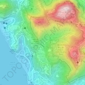
Nom : Carte topographique Pok Fu Lam Reservoir, altitude, relief.
Altitude moyenne : 192 m
Altitude minimum : -2 m
Altitude maximum : 534 m
Autres cartes topographiques
Cliquez sur une carte pour visualiser sa topographie, son altitude et son relief.
Sai Wan
China > Hong Kong > Hong Kong Island
Sai Wan, Central and Western District, Hong Kong Island, Hong Kong, China
Altitude moyenne : 81 m