
Carte topographique Derbyshire
Carte interactive
Cliquez sur la carte pour afficher l’altitude.
À propos de cette carte
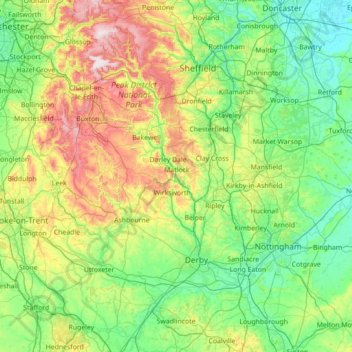
Nom : Carte topographique Derbyshire, altitude, relief.
Altitude moyenne : 144 m
Altitude minimum : 0 m
Altitude maximum : 637 m
Autres cartes topographiques
Cliquez sur une carte pour visualiser sa topographie, son altitude et son relief.
Burton-on-Trent
United Kingdom > England > East Staffordshire > Burton-on-Trent
Burton-on-Trent, East Staffordshire, Staffordshire, England, DE14 1JN, United Kingdom
Altitude moyenne : 69 m
Denstone
United Kingdom > England > East Staffordshire > Denstone
Denstone, East Staffordshire, Staffordshire, West Midlands, England, ST14 5GB, United Kingdom
Altitude moyenne : 118 m