
Carte topographique Kessenich
Carte interactive
Cliquez sur la carte pour afficher l’altitude.
À propos de cette carte
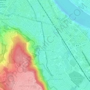
Nom : Carte topographique Kessenich, altitude, relief.
Altitude moyenne : 84 m
Altitude minimum : 42 m
Altitude maximum : 175 m
Autres cartes topographiques
Cliquez sur une carte pour visualiser sa topographie, son altitude et son relief.
Lengsdorf
Duitsland > Noordrijn-Westfalen > Bonn
Lengsdorf, Hardtberg, Bonn, Noordrijn-Westfalen, 53127, Duitsland
Altitude moyenne : 115 m
Bonn
Duitsland > Noordrijn-Westfalen > Bonn
Bonn, Noordrijn-Westfalen, 53111, Duitsland
Altitude moyenne : 138 m
St. Adelheid-Brunnen
Duitsland > Noordrijn-Westfalen > Bonn
St. Adelheid-Brunnen, Brunnenweg, Pützchen, Pützchen/Bechlinghoven, Bonn-Beuel, Bonn, Noordrijn-Westfalen, 53229, Duitsland
Altitude moyenne : 77 m