
Carte topographique Falkirk
Carte interactive
Cliquez sur la carte pour afficher l’altitude.
À propos de cette carte
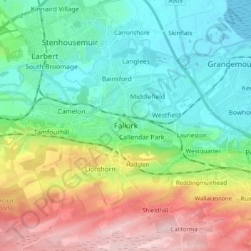
Nom : Carte topographique Falkirk, altitude, relief.
Lieu : Falkirk, Scotland, FK1 1ED, United Kingdom (55.95920 -3.82438 56.03920 -3.74438)
Altitude moyenne : 69 m
Altitude minimum : -1 m
Altitude maximum : 207 m
Falkirk is located in an area of undulating topography between the Slamannan Plateau and the upper reaches of the Firth of Forth. The area to the north of Falkirk is part of the floodplain of the River Carron. Two tributaries of the River Carron - the East Burn and the West Burn flow through the town and form part of its natural drainage system. Falkirk sits at between 50 metres (164 ft) and 125 metres (410 ft) above sea level.