
Carte topographique Khatanga
Carte interactive
Cliquez sur la carte pour afficher l’altitude.
À propos de cette carte
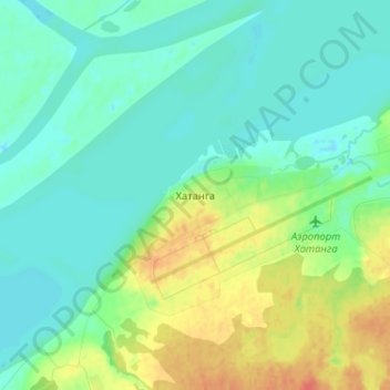
Nom : Carte topographique Khatanga, altitude, relief.
Altitude moyenne : 11 m
Altitude minimum : -4 m
Altitude maximum : 38 m
Khatanga (Russian: Ха́танга) is a rural locality (a selo) in Taymyrsky Dolgano-Nenetsky District of Krasnoyarsk Krai, Russia, located on the Khatanga River on the Taymyr Peninsula. It is one of the northernmost inhabited localities in Russia. Its elevation is 30 metres (98 ft) above sea level. As of the 2002 Census, its population was 3,450.