
Carte topographique River Foyle
Carte interactive
Cliquez sur la carte pour afficher l’altitude.
À propos de cette carte
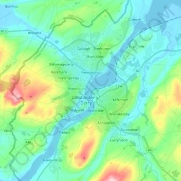
Nom : Carte topographique River Foyle, altitude, relief.
Altitude moyenne : 61 m
Altitude minimum : -4 m
Altitude maximum : 273 m
Autres cartes topographiques
Cliquez sur une carte pour visualiser sa topographie, son altitude et son relief.
Magilligan
United Kingdom > Northern Ireland > Londonderry/Derry
Magilligan, Aughil, Londonderry/Derry, County Londonderry, Northern Ireland, United Kingdom
Altitude moyenne : 81 m
Lough Foyle
United Kingdom > Northern Ireland > Londonderry/Derry
Lough Foyle, Londonderry/Derry, County Londonderry, Northern Ireland, United Kingdom
Altitude moyenne : 61 m
Termonbacca
United Kingdom > Northern Ireland > Londonderry/Derry
Termonbacca, Londonderry/Derry, County Londonderry, Northern Ireland, United Kingdom
Altitude moyenne : 74 m
Mullaghmore
United Kingdom > Northern Ireland > Londonderry/Derry
Mullaghmore, Londonderry/Derry, County Londonderry, Northern Ireland, United Kingdom
Altitude moyenne : 389 m
Loughermore
United Kingdom > Northern Ireland > Londonderry/Derry
Loughermore, Londonderry/Derry, County Londonderry, Northern Ireland, United Kingdom
Altitude moyenne : 294 m
Edenballymore
United Kingdom > Northern Ireland > Londonderry/Derry
Edenballymore, Londonderry/Derry, County Londonderry, Northern Ireland, United Kingdom
Altitude moyenne : 41 m
Benbradagh
United Kingdom > Northern Ireland > Londonderry/Derry
Benbradagh, Londonderry/Derry, County Londonderry, Northern Ireland, BT47 4QN, United Kingdom
Altitude moyenne : 252 m