
Carte topographique Steel Bay - Newland Backwater Gippsland Lakes Reserve
Carte interactive
Cliquez sur la carte pour afficher l’altitude.
À propos de cette carte
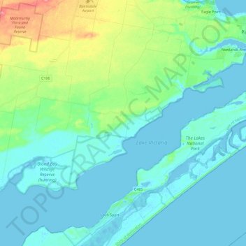
Nom : Carte topographique Steel Bay - Newland Backwater Gippsland Lakes Reserve, altitude, relief.
Altitude moyenne : 17 m
Altitude minimum : -9 m
Altitude maximum : 83 m
Autres cartes topographiques
Cliquez sur une carte pour visualiser sa topographie, son altitude et son relief.
Raymond Island
Australia > Victoria > Paynesville
Raymond Island, Paynesville, Shire of East Gippsland, Victoria, 3880, Australia
Altitude moyenne : 2 m
Paynesville
Australia > Victoria > Paynesville
Paynesville, Shire of East Gippsland, Victoria, 3880, Australia
Altitude moyenne : 5 m