
Carte topographique Weitnau
Carte interactive
Cliquez sur la carte pour afficher l’altitude.
À propos de cette carte
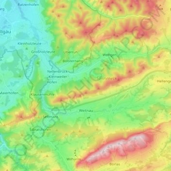
Nom : Carte topographique Weitnau, altitude, relief.
Altitude moyenne : 887 m
Altitude minimum : 688 m
Altitude maximum : 1 236 m
Autres cartes topographiques
Cliquez sur une carte pour visualiser sa topographie, son altitude et son relief.
Schochen
Deutschland > Bayern > Landkreis Oberallgäu > Oberstdorf
Schochen, Oberstdorf, Landkreis Oberallgäu, Bayern, Deutschland
Altitude moyenne : 1 643 m
Weidach
Deutschland > Bayern > Landkreis Oberallgäu > Oberstdorf > Tiefenbach
Weidach, Tiefenbach, Oberstdorf, Landkreis Oberallgäu, Bayern, 87561, Deutschland
Altitude moyenne : 979 m