
Carte topographique Gorgan
Carte interactive
Cliquez sur la carte pour afficher l’altitude.
À propos de cette carte
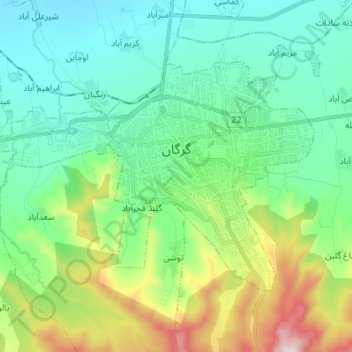
Nom : Carte topographique Gorgan, altitude, relief.
Lieu : Gorgan, بخش مرکزی, Gorgan County, Golestan Province, Iran (36.79485 54.36287 36.86619 54.48563)
Altitude moyenne : 180 m
Altitude minimum : 7 m
Altitude maximum : 641 m
Autres cartes topographiques
Cliquez sur une carte pour visualiser sa topographie, son altitude et son relief.
پارک جنگلی قرق
Iran > Golestan Province > Gorgan County
پارک جنگلی قرق, Gorgan County, Golestan Province, Iran
Altitude moyenne : 1 247 m