
Faire un don
Équipez-vous pour votre prochaine aventure :
En tant que Partenaire Amazon, ce site perçoit une commission sur les achats éligibles sans surcoût pour vous.
Carte topographique Morro Solar
Cliquez sur la carte pour afficher l’altitude.
Faire un don
Équipez-vous pour votre prochaine aventure :
En tant que Partenaire Amazon, ce site perçoit une commission sur les achats éligibles sans surcoût pour vous.
Morro Solar
Morro Solar, a cluster of hills, is roughly 251 metres (823 ft) in elevation. It lies near Chorrillos, a southern suburb of Lima, occupying an area of 7.48 square kilometres (2.89 sq mi). Alexander George Findlay described it as "a remarkable cluster of hills, standing on a sandy plain; when seen from the southward it has the appearance of an island in the shape of a quoin, sloping to the westward, and falling very abruptly in-shore; on its sea face, however, it terminates in a steep cliff, with a sandy bay on each side." The sandy shore between Morro Solar and Lurin is known as Conchan Beach. The southwest point of Morro Solar is formed by the Solar Point, located 10 miles (16 km) from San Francisco Island and 10 miles (16 km) to the southwest of Callao. Its sea face terminates in a steep cliff at Codo Point with a sandy bay on each side. The northern side of Morro Solar is the Chorillos Bay which was used in the 1860s for anchoring of ships only in exceptional circumstances as the bottom of the sea consisted of hard sand, clay stones and boulders, which was upsetting the stability of the ships. The summit of the hill range provides scenic views of the Bay of Lima, the city of Lima and South Spas.
Faire un don
Équipez-vous pour votre prochaine aventure :
En tant que Partenaire Amazon, ce site perçoit une commission sur les achats éligibles sans surcoût pour vous.
À propos de cette carte
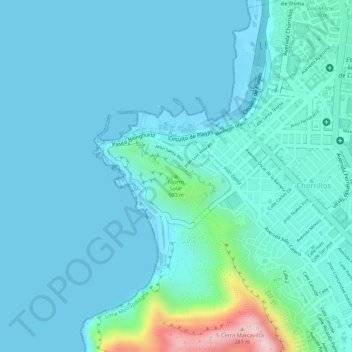
Nom : Carte topographique Morro Solar, altitude, relief.
Altitude moyenne : 38 m
Altitude minimum : -1 m
Altitude maximum : 281 m
Faire un don
Équipez-vous pour votre prochaine aventure :
En tant que Partenaire Amazon, ce site perçoit une commission sur les achats éligibles sans surcoût pour vous.
Autres cartes topographiques
Cliquez sur une carte pour visualiser sa topographie, son altitude et son relief.