
Carte topographique Sai Kung East Country Park
Carte interactive
Cliquez sur la carte pour afficher l’altitude.
À propos de cette carte
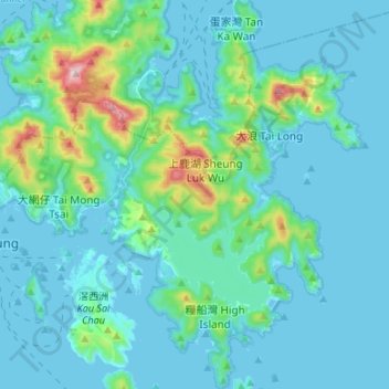
Nom : Carte topographique Sai Kung East Country Park, altitude, relief.
Altitude moyenne : 62 m
Altitude minimum : -5 m
Altitude maximum : 466 m
Autres cartes topographiques
Cliquez sur une carte pour visualiser sa topographie, son altitude et son relief.
High Island Reservoir
High Island Reservoir, Sai Kung Man Yee Road, High Island, Lan Nai Wan, Sai Kung District, Hong Kong, PRC
Altitude moyenne : 78 m