
Carte topographique Anyang
Carte interactive
Cliquez sur la carte pour afficher l’altitude.
À propos de cette carte
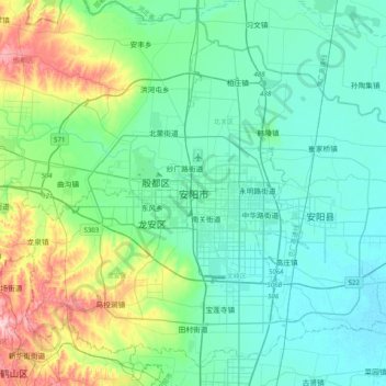
Nom : Carte topographique Anyang, altitude, relief.
Lieu : Anyang, Beiguan District, Anyang City, Henan, China (35.94236 114.17633 36.26236 114.49633)
Altitude moyenne : 102 m
Altitude minimum : 56 m
Altitude maximum : 275 m
Anyang spans a total area of 7,355 square kilometres (2,840 sq mi). The city's elevation is generally higher in the west, with the foothills of the Taihang Mountains running through the area, and lower in the east, which comprises part of the North China Plain.
Autres cartes topographiques
Cliquez sur une carte pour visualiser sa topographie, son altitude et son relief.
Fuwa
China > Henan > Shangcheng County > Duntangcun
Fuwa, Duntangcun, Shangcheng County, Xinyang, Henan, China
Altitude moyenne : 142 m
Cuiyunlu Subdistrict
China > Henan > Luolong District
Cuiyunlu Subdistrict, Luolong District, Luoyang, Henan, China
Altitude moyenne : 148 m
Xichuan
China > Henan > Xichuan County > Xichuan
Xichuan, Xichuan County, Nanyang City, Henan, China
Altitude moyenne : 327 m
Suiping County
China > Henan > Suiping County > Zhumadian City
Suiping County, Zhumadian City, Henan, China
Altitude moyenne : 91 m
Mangshan Subdistrict
China > Henan > Mangshan Subdistrict
Mangshan Subdistrict, Laocheng District, Luoyang City, Henan, China
Altitude moyenne : 216 m