
Carte topographique Wienerberg
Carte interactive
Cliquez sur la carte pour afficher l’altitude.
À propos de cette carte
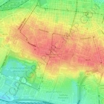
Nom : Carte topographique Wienerberg, altitude, relief.
Lieu : Wienerberg, Wien, 1102, Österreich (48.16505 16.36398 48.16515 16.36408)
Altitude moyenne : 223 m
Altitude minimum : 187 m
Altitude maximum : 251 m
Autres cartes topographiques
Cliquez sur une carte pour visualiser sa topographie, son altitude et son relief.
KG Pötzleinsdorf
KG Pötzleinsdorf, Währing, Wien, 1180, Österreich
Altitude moyenne : 273 m
Hinterhainbach
Hinterhainbach, KG Hadersdorf, Penzing, Wien, 1140, Österreich
Altitude moyenne : 395 m
KG Inzersdorf
KG Inzersdorf, Liesing, Wien, 1230, Österreich
Altitude moyenne : 199 m
Kurpark Oberlaa
Kurpark Oberlaa, KG Oberlaa Stadt, Favoriten, Wien, 1100, Österreich
Altitude moyenne : 208 m
Lainzer Tiergarten
Lainzer Tiergarten, Linzer Straße, KG Hütteldorf, Penzing, Wien, 1140, Österreich
Altitude moyenne : 340 m
Schloss Neugebäude
Schloss Neugebäude, Neugebäudestraße, KG Kaiserebersdorf, Simmering, Wien, 1110, Österreich
Altitude moyenne : 167 m
Hundsturm
Hundsturm, KG Margareten, Margareten, Wien, 1050, Österreich, Stefan-Weber-Park
Altitude moyenne : 202 m
KG Stammersdorf
KG Stammersdorf, Floridsdorf, Wien, 1210, Österreich
Altitude moyenne : 196 m
Türkenschanzpark
Türkenschanzpark, KG Währing, Währing, Wien, 1180, Österreich
Altitude moyenne : 221 m
KG Mariahilf
KG Mariahilf, Mariahilf, Wien, 1060, Österreich
Altitude moyenne : 201 m
KG Hadersdorf
KG Hadersdorf, Penzing, Wien, 1140, Österreich
Altitude moyenne : 358 m
KG Leopoldstadt
Österreich > Wien > Wien > Neukagran
KG Leopoldstadt, Leopoldstadt, Wien, 1020, Österreich
Altitude moyenne : 171 m
Bischofmais
Bischofmais, KG Auhof, Hietzing, Wien, 1130, Österreich
Altitude moyenne : 282 m
KG Schönbrunn
KG Schönbrunn, Hietzing, Wien, 1130, Österreich
Altitude moyenne : 215 m