Géolocaliser

Carte topographique Lochau

Carte interactive

Cliquez sur la carte pour afficher l’altitude.

À propos de cette carte

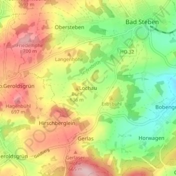
Nom : Carte topographique Lochau, altitude, relief.

Lieu : Lochau, Bad Steben, Landkreis Hof, Bayern, 95138, Deutschland (50.33103 11.60442 50.37103 11.64442)

Altitude moyenne : 613 m

Altitude minimum : 523 m

Altitude maximum : 711 m

Autres cartes topographiques

Cliquez sur une carte pour visualiser sa topographie, son altitude et son relief.

Carlsgrün

Deutschland > Bayern > Landkreis Hof > Bad Steben

Carlsgrün, Bad Steben, Landkreis Hof, Bayern, 95138, Deutschland

Altitude moyenne : 612 m

Thierbach

Deutschland > Bayern > Landkreis Hof > Bad Steben > Thierbach

Thierbach, Bad Steben, Landkreis Hof, Bayern, 95138, Deutschland

Altitude moyenne : 569 m