
Carte topographique Harford County
Carte interactive
Cliquez sur la carte pour afficher l’altitude.
À propos de cette carte
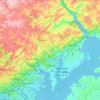
Nom : Carte topographique Harford County, altitude, relief.
Lieu : Harford County, Maryland, United States of America (39.25801 -76.56923 39.72121 -76.03564)
Altitude moyenne : 70 m
Altitude minimum : -3 m
Altitude maximum : 237 m
Harford County straddles the border between the rolling hills of the Piedmont Plateau and the flatlands of the Atlantic Coastal Plain along the Chesapeake Bay and its tributaries. The county's development is a mix of rural and suburban, with denser development in the larger towns of Aberdeen and Bel Air and along Route 40 and other major arteries leading out of Baltimore. The highest elevations are in the north and northwest of the county, reaching 805 ft. near the Pennsylvania border in the county's northwestern corner. The lowest elevation is sea level along the Chesapeake Bay.
Autres cartes topographiques
Cliquez sur une carte pour visualiser sa topographie, son altitude et son relief.
Wicomico County
United States of America > Maryland
Wicomico County, Maryland, United States of America
Altitude moyenne : 9 m
Prince George's County
United States of America > Maryland
Prince George's County, Maryland, United States of America
Altitude moyenne : 45 m
Bethesda
United States of America > Maryland > Bethesda
Bethesda, Montgomery County, Maryland, United States of America
Altitude moyenne : 81 m
Bethesda
United States of America > Maryland > Bethesda
Bethesda, Montgomery County, Maryland, 22814, United States of America
Altitude moyenne : 86 m