
Carte topographique Cedros Island
Carte interactive
Cliquez sur la carte pour afficher l’altitude.
Cedros Island
Cedros Island (Isla de Cedros, "island of cedars" in Spanish) is an island in the Pacific Ocean belonging to the state of Baja California, Mexico. The dry and rocky island had a population of 1,350 in 2005 and has an area of 348 square kilometres (134 sq mi) which includes the area of several small nearby islands. Cedros Island is mountainous, reaching a maximum elevation of 1,205 metres (3,953 ft). The economy is based on commercial fishing and salt production. Cedros has a distinctive flora and the traces of some of the earliest human beings in the New World. The ocean around the island is popular with sport fishermen.
À propos de cette carte
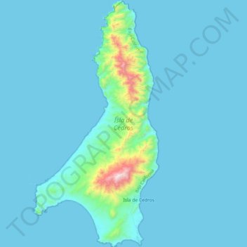
Nom : Carte topographique Cedros Island, altitude, relief.
Altitude moyenne : 67 m
Altitude minimum : -3 m
Altitude maximum : 1 178 m
Autres cartes topographiques
Cliquez sur une carte pour visualiser sa topographie, son altitude et son relief.
San Miguel (Cíbolas de Mar)
Mexico > Baja California > Municipio de Ensenada > Ensenada
Altitude moyenne : 57 m