
Carte topographique Biłgoraj
Carte interactive
Cliquez sur la carte pour afficher l’altitude.
À propos de cette carte
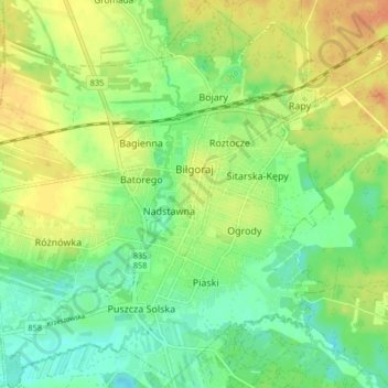
Nom : Carte topographique Biłgoraj, altitude, relief.
Altitude moyenne : 199 m
Altitude minimum : 182 m
Altitude maximum : 219 m
The name of the town comes from a hill called Biely Goraj, on which Biłgoraj was founded in the 16th century. Biłgoraj lies in northern part of Sandomierz Basin, near Roztocze. The town is surrounded by Solska Forest, not far away (20 km (12 mi)) from Roztocze National Park. Administratively, since 1474 it has been tied with the city of Lublin. In that year, Lublin Voivodeship was split away from Sandomierz Voivodeship. An average July temperature in Biłgoraj is 18 °C (64 °F), an average January temperature −2.8 °C (27.0 °F). The town is crossed by four small rivers: Biala Lada, Czarna Lada, Osa and Próchnica. Biłgoraj lies on the elevations ranging from 190 to 205 meters above sea level. The area of the town is 20 square kilometres (8 square miles), of which forests covers 9%. Built-up area stretches along eastern bank of the Biala Lada, for 5 km (3 mi) (north–south) and 3 km (2 mi) (west–east).