
Carte topographique Nankai
Carte interactive
Cliquez sur la carte pour afficher l’altitude.
Nankai
Nankai District is located in the south-west corner of the urban Tianjin, bordered by Hongqiao District to the north, Hebei and Heping Districts to the north-east, Hexi District to the east and Xiqing District to the south-west. It occupies an area of 40.64 square kilometres (15.69 sq mi). The natural topography is characterised by higher elevation in the north of the district and a lower elevation in the south, with the average altitude being 3 metres.
À propos de cette carte
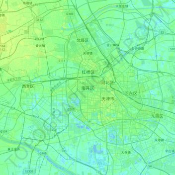
Nom : Carte topographique Nankai, altitude, relief.
Lieu : Nankai, Nankai District, Tianjin, 300084, China (38.97701 116.98395 39.29701 117.30395)
Altitude moyenne : 5 m
Altitude minimum : -5 m
Altitude maximum : 19 m
Autres cartes topographiques
Cliquez sur une carte pour visualiser sa topographie, son altitude et son relief.