
Carte topographique Kiveton Park
Carte interactive
Cliquez sur la carte pour afficher l’altitude.
À propos de cette carte
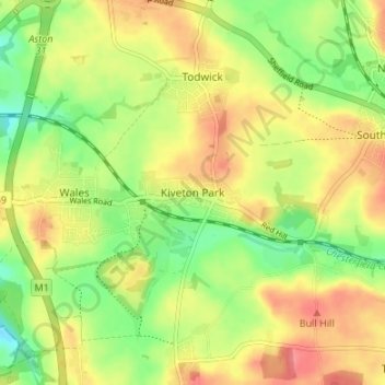
Nom : Carte topographique Kiveton Park, altitude, relief.
Altitude moyenne : 104 m
Altitude minimum : 71 m
Altitude maximum : 135 m
Kiveton Park is located at approximately 53°20′30″N 1°15′30″W / 53.34167°N 1.25833°W / 53.34167; -1.25833, at an elevation of around 330 feet (100 m) above sea level, and is located 8 miles (13 km) west of Worksop, and 11 miles (18 km) south-east of both Sheffield, and Rotherham respectively. It lies on the B6059 road (Station Road) and is served by two railway stations: Kiveton Bridge and Kiveton Park. The Chesterfield Canal lies to the south, while the villages of Todwick and South Anston are to the north and east. Kiveton Park lays claim to being in Rotherham Borough Council, has a Sheffield postcode, a Worksop telephone code, and has the Chesterfield Canal running through it. The village has two railway stations: Kiveton Bridge railway station in the centre of the village; and Kiveton Park railway station.
Autres cartes topographiques
Cliquez sur une carte pour visualiser sa topographie, son altitude et son relief.
South Anston
United Kingdom > England > Rotherham
South Anston, Rotherham, South Yorkshire, England, S25 5DT, United Kingdom
Altitude moyenne : 105 m
Aston
United Kingdom > England > Rotherham
Aston, Rotherham, South Yorkshire, England, S26 2AP, United Kingdom
Altitude moyenne : 89 m
Waverley
United Kingdom > England > Rotherham
Waverley, Rotherham, South Yorkshire, England, S60 8AH, United Kingdom
Altitude moyenne : 65 m
Greasbrough
United Kingdom > England > Rotherham
Greasbrough, Rotherham, South Yorkshire, England, S61 4ES, United Kingdom
Altitude moyenne : 69 m
Hellaby
United Kingdom > England > Rotherham
Hellaby, Rotherham, South Yorkshire, England, United Kingdom
Altitude moyenne : 113 m
North Anston
United Kingdom > England > Rotherham
North Anston, Rotherham, South Yorkshire, England, S25 4AL, United Kingdom
Altitude moyenne : 106 m
Wickersley
United Kingdom > England > Rotherham > Bramley
Wickersley, Bramley, Rotherham, South Yorkshire Mayoral Combined Authority, England, United Kingdom
Altitude moyenne : 116 m
Aughton
United Kingdom > England > Rotherham
Ulley, Aughton, Rotherham, South Yorkshire Mayoral Combined Authority, England, United Kingdom
Altitude moyenne : 92 m
Bramley
United Kingdom > England > Rotherham
Bramley, Rotherham, South Yorkshire Mayoral Combined Authority, England, S66 2RT, United Kingdom
Altitude moyenne : 116 m
Sheffield and South Yokshire Navigation
United Kingdom > England > Rotherham > Thrybergh
Sheffield and South Yokshire Navigation, Thrybergh, Rotherham, South Yorkshire Mayoral Combined Authority, England, S64 5TH, United Kingdom
Altitude moyenne : 39 m
Thrybergh
United Kingdom > England > Rotherham
Thrybergh, Rotherham, South Yorkshire, England, United Kingdom
Altitude moyenne : 48 m
Ravenfield
United Kingdom > England > Rotherham
Ravenfield, Bramley, Rotherham, South Yorkshire, England, United Kingdom
Altitude moyenne : 86 m
Thurcroft
United Kingdom > England > Rotherham > Thurcroft
Thurcroft, Rotherham, South Yorkshire, England, United Kingdom
Altitude moyenne : 111 m
Morthen
United Kingdom > England > Rotherham
Morthen, Rotherham, South Yorkshire Mayoral Combined Authority, England, S66 9JH, United Kingdom
Altitude moyenne : 103 m
Todwick
United Kingdom > England > Rotherham > Todwick
Todwick, Rotherham, South Yorkshire Mayoral Combined Authority, England, United Kingdom
Altitude moyenne : 105 m
Anston Stones Wood
United Kingdom > England > Rotherham > North Anston
Anston Stones Wood, Anston, North Anston, Rotherham, South Yorkshire, England, United Kingdom
Altitude moyenne : 102 m
Brinsworth
United Kingdom > England > Rotherham > Catcliffe
Brinsworth, Catcliffe, Rotherham, South Yorkshire Mayoral Combined Authority, England, United Kingdom
Altitude moyenne : 53 m
Treeton
United Kingdom > England > Rotherham
Treeton, Rotherham, South Yorkshire, England, S60 5PP, United Kingdom
Altitude moyenne : 58 m
Carr
United Kingdom > England > Rotherham > Laughton-en-le-Morthen > Carr
Carr, Laughton-en-le-Morthen, Rotherham, Yorkshire and the Humber, England, S66 8PW, United Kingdom
Altitude moyenne : 112 m
Harthill
United Kingdom > England > Rotherham
Harthill, Rotherham, South Yorkshire Mayoral Combined Authority, England, S26 7YG, United Kingdom
Altitude moyenne : 116 m
Bradgate Park
United Kingdom > England > Rotherham
Bradgate Park, Bradgate, Rotherham, Yorkshire and the Humber, England, United Kingdom
Altitude moyenne : 69 m
Swallownest
United Kingdom > England > Rotherham
Swallownest, Rotherham, South Yorkshire Mayoral Combined Authority, England, S26 4TT, United Kingdom
Altitude moyenne : 72 m
Aughton
United Kingdom > England > Rotherham
Aughton, Rotherham, South Yorkshire Mayoral Combined Authority, England, S26 3XH, United Kingdom
Altitude moyenne : 77 m
Guilthwaite
United Kingdom > England > Rotherham
Whiston, Guilthwaite, Rotherham, South Yorkshire Mayoral Combined Authority, England, United Kingdom
Altitude moyenne : 72 m
Woodall
United Kingdom > England > Rotherham > Woodall
Woodall, Rotherham, Yorkshire and the Humber, England, S26 7UN, United Kingdom
Altitude moyenne : 109 m
Wales
United Kingdom > England > Rotherham
Wales, Rotherham, South Yorkshire Mayoral Combined Authority, England, S26 5RT, United Kingdom
Altitude moyenne : 95 m
Fir Hill
United Kingdom > England > Rotherham
Fir Hill, Rotherham, Yorkshire and the Humber, England, S26 7YP, United Kingdom
Altitude moyenne : 126 m
Aston cum Aughton
United Kingdom > England > Rotherham
Aston cum Aughton, Rotherham, Yorkshire and the Humber, England, United Kingdom
Altitude moyenne : 78 m
Firbeck
United Kingdom > England > Rotherham
Firbeck, Rotherham, South Yorkshire, England, United Kingdom
Altitude moyenne : 62 m
Thorpe Hesley
United Kingdom > England > Rotherham
Thorpe Hesley, Rotherham, South Yorkshire, England, S61 2QG, United Kingdom
Altitude moyenne : 100 m