Géolocaliser

Carte topographique Anvil Rock

Cliquez sur la carte pour afficher l’altitude.

À propos de cette carte

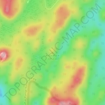
Nom : Carte topographique Anvil Rock, altitude, relief.

Lieu : Anvil Rock, Glen Innes Severn Council, New South Wales, Australia (-29.55216 152.31495 -29.55206 152.31505)

Altitude moyenne : 981 m

Altitude minimum : 897 m

Altitude maximum : 1 082 m

Autres cartes topographiques

Cliquez sur une carte pour visualiser sa topographie, son altitude et son relief.

Sydney

Australia > New South Wales

Sydney's topography is characterized by a diverse landscape that seamlessly blends coastal features with inland plateaus. The city is divided into two primary regions: the relatively flat Cumberland Plain to the south and west of Sydney Harbour, and the elevated Hornsby Plateau to the north. The Cumberland…

Altitude moyenne : 51 m

Lithgow City Council

Australia > New South Wales

Altitude moyenne : 713 m

Newcastle

Australia > New South Wales

Altitude moyenne : 5 m

Baulkham Hills

Australia > New South Wales

Altitude moyenne : 93 m

Rylstone

Australia > New South Wales

Altitude moyenne : 657 m

Oberon Council

Australia > New South Wales

Altitude moyenne : 899 m

Castlereagh River

Australia > New South Wales

The Castlereagh rises 20 km west of Coonabarabran in the heart of the Warrumbungle mountains at an elevation of about 850 metres. From its commencement upstream in the mountains the river initially flows east through the town of Coonabarabran. It then arcs round south and southwesterly to the village of…

Altitude moyenne : 240 m

Sydney CBD

Australia > New South Wales > Sydney

Altitude moyenne : 25 m

Armidale

Australia > New South Wales

Altitude moyenne : 1 036 m

Bowral

Australia > New South Wales

Altitude moyenne : 690 m

Goulburn

Australia > New South Wales

Owing to its elevation, Goulburn has an oceanic climate (Cfb) with warm summers and cool winters; with a high diurnal range. Its climate is variable much of the year, though generally dry with maximum temperatures ranging from 11.8 °C (53.2 °F) in July to 28.3 °C (82.9 °F) in January. Rainfall is…

Altitude moyenne : 666 m

Lilyfield

Australia > New South Wales > Sydney

Altitude moyenne : 18 m

Taree

Australia > New South Wales

Altitude moyenne : 17 m

Botany

Australia > New South Wales > Sydney

Altitude moyenne : 6 m

Bunyah

Australia > New South Wales

Altitude moyenne : 137 m

Modanville

Australia > New South Wales

Altitude moyenne : 118 m

Lake Keepit

Australia > New South Wales

Altitude moyenne : 357 m

Penrith

Australia > New South Wales > Sydney > Penrith

Penrith is a city in New South Wales, Australia, located in Greater Western Sydney, 55 kilometres (31 mi) west of the Sydney central business district on the banks of the Nepean River, on the outskirts of the Cumberland Plain. Its elevation is 32 metres (105 ft).

Altitude moyenne : 34 m

Botany Bay

Australia > New South Wales > Sydney

Altitude moyenne : 8 m

Woolgoolga

Australia > New South Wales

Altitude moyenne : 29 m

Avalon Beach

Australia > New South Wales

Altitude moyenne : 24 m

Mudgee

Australia > New South Wales

Altitude moyenne : 535 m

Cecil Hills

Australia > New South Wales

Altitude moyenne : 77 m

Eden

Australia > New South Wales

Altitude moyenne : 55 m

Goonellabah

Australia > New South Wales

Altitude moyenne : 86 m

Quakers Hill

Australia > New South Wales

Altitude moyenne : 35 m

Hazelbrook

Australia > New South Wales

Hazelbrook is a town in New South Wales, Australia (Elevation: 675 metres) It is located 91 kilometres west of Sydney and 16 kilometres east of Katoomba in the Blue Mountains on the Great Western Highway.

Altitude moyenne : 610 m

Blayney Shire Council

Australia > New South Wales

Altitude moyenne : 818 m

Byron Shire Council

Australia > New South Wales

Altitude moyenne : 104 m

Tintenbar

Australia > New South Wales

Altitude moyenne : 49 m

Castle Hill

Australia > New South Wales > Sydney

Altitude moyenne : 123 m

Cooma

Australia > New South Wales

Altitude moyenne : 869 m

Tumbarumba

Australia > New South Wales

Altitude moyenne : 774 m

South Nowra

Australia > New South Wales

Altitude moyenne : 44 m

Broughton Island

Australia > New South Wales

Altitude moyenne : 3 m

Urbenville

Australia > New South Wales

Altitude moyenne : 474 m

Stuarts Point

Australia > New South Wales

Altitude moyenne : 9 m

Dalwood

Australia > New South Wales

Altitude moyenne : 42 m

Sofala

Australia > New South Wales

Altitude moyenne : 747 m

Wingham

Australia > New South Wales

Altitude moyenne : 47 m

Cabramurra

Australia > New South Wales

Altitude moyenne : 1 226 m

Byron Bay

Australia > New South Wales

Byron Bay, located in northeastern New South Wales, Australia, is characterized by diverse topography shaped by its geological history. The town is part of the erosion caldera of the ancient Tweed Volcano, which erupted approximately 23 million years ago, resulting in the rich volcanic soils that define the…

Altitude moyenne : 7 m

Redfern

Australia > New South Wales

Altitude moyenne : 30 m

Blackheath

Australia > New South Wales

Blackheath (postcode: 2785) is an Australian town located near the highest point of the Blue Mountains, between Katoomba and Mount Victoria in New South Wales. The town's altitude is about 1,065 metres (3,494 ft) AHD  and it is located about 120 kilometres (75 mi) west north-west of Sydney, 11 kilometres…

Altitude moyenne : 893 m

Epping

Australia > New South Wales > Sydney

Altitude moyenne : 96 m

Bega

Australia > New South Wales

Altitude moyenne : 44 m

Crookwell

Australia > New South Wales

Crookwell is a small town located in the Southern Tablelands of New South Wales, Australia, in the Upper Lachlan Shire. At the 2016 census, Crookwell had a population of 2,641. The town is at a relatively high altitude of 887 metres and there are several snowfalls during the winter months. The nearest major…

Altitude moyenne : 904 m

North Sydney

Australia > New South Wales > Sydney

Altitude moyenne : 50 m

Tweed Shire Council

Australia > New South Wales

Altitude moyenne : 212 m

Wollemi National Park

Australia > New South Wales

Altitude moyenne : 521 m

Warialda

Australia > New South Wales

Altitude moyenne : 420 m

Kybeyan

Australia > New South Wales

Altitude moyenne : 1 016 m

New Italy

Australia > New South Wales

Altitude moyenne : 34 m

Wolumla

Australia > New South Wales

Altitude moyenne : 147 m

Mount Victoria

Australia > New South Wales

Mount Victoria (postcode: 2786) is a small township in the Blue Mountains of New South Wales, Australia. Mount Victoria is geographically the western most village and suburb of Greater Sydney on the great western highway in the City of Blue Mountains, located about 120 kilometres (75 mi) west-northwest by road…

Altitude moyenne : 901 m

Glenbrook

Australia > New South Wales

Altitude moyenne : 168 m

Coolah

Australia > New South Wales

Altitude moyenne : 569 m

Putty

Australia > New South Wales

Altitude moyenne : 420 m

Cooranbong

Australia > New South Wales

Altitude moyenne : 72 m

Yass

Australia > New South Wales

Yass is located 280 km south-west of Sydney, on the Hume Highway. The Yass River, which is a tributary of the Murrumbidgee River, flows through the town. Yass is 59 km from Canberra; lying at an elevation of 505 m AMSL.

Altitude moyenne : 533 m

Port Macquarie

Australia > New South Wales

Altitude moyenne : 5 m

Heathcote

Australia > New South Wales > Sydney

Altitude moyenne : 148 m

Rosebery

Australia > New South Wales > Sydney

Altitude moyenne : 19 m

Seaforth

Australia > New South Wales > Sydney

Altitude moyenne : 49 m

Mullumbimby

Australia > New South Wales

Altitude moyenne : 29 m

Moss Vale

Australia > New South Wales

Altitude moyenne : 673 m

Manly

Australia > New South Wales

Altitude moyenne : 17 m

Seven Hills

Australia > New South Wales

Altitude moyenne : 49 m

Surry Hills

Australia > New South Wales > Sydney

Altitude moyenne : 35 m

Coogee

Australia > New South Wales

Altitude moyenne : 35 m

Turramurra

Australia > New South Wales > Sydney

Altitude moyenne : 143 m

Kyogle Council

Australia > New South Wales

Altitude moyenne : 315 m

Tyalgum

Australia > New South Wales

Altitude moyenne : 161 m

Brandy Hill

Australia > New South Wales

Altitude moyenne : 15 m

Holsworthy

Australia > New South Wales > Sydney

Altitude moyenne : 121 m

Bondi

Australia > New South Wales

Altitude moyenne : 49 m

Nimmitabel

Australia > New South Wales

Altitude moyenne : 1 051 m

Parkes Shire Council

Australia > New South Wales

Altitude moyenne : 307 m

Warriewood

Australia > New South Wales > Sydney

Altitude moyenne : 33 m

West Pennant Hills

Australia > New South Wales

Altitude moyenne : 130 m

Redhead

Australia > New South Wales > Newcastle-Maitland

Altitude moyenne : 30 m

Lane Cove National Park

Australia > New South Wales > Sydney

The park includes areas of land which are part of Ku-ring-gai, Ryde, and Hornsby local government areas with small areas of the park in Willoughby, Lane Cove and Hunter's Hill local government areas on the banks of the lower reaches of the river. The park is surrounded on all sides by developed suburban areas…

Altitude moyenne : 81 m

Lavender Bay

Australia > New South Wales > Sydney

Altitude moyenne : 29 m

Équipez-vous pour votre prochaine aventure :

🛏️Sacs de couchage - Sacs de couchage pour différentes températures
🗺️Carte du monde à gratter - Cadeau idéal pour suivre ses explorations passées
🥾Chaussures de marche - Chaussures légères et confortables pour sentiers et balades
🩳Pantalons de randonnée - Pantalons résistants et confortables
🎒Housse de pluie pour sac à dos - Protection supplémentaire pour garder votre contenu au sec

En tant que Partenaire Amazon, ce site perçoit une commission sur les achats éligibles sans surcoût pour vous.