
Carte topographique Kyritz
Cliquez sur la carte pour afficher l’altitude.
À propos de cette carte
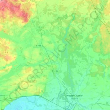
Nom : Carte topographique Kyritz, altitude, relief.
Lieu : Kyritz, Ostprignitz-Ruppin, Brandenburg, 16866, Germany (52.89267 12.18952 53.05692 12.55734)
Altitude moyenne : 51 m
Altitude minimum : 26 m
Altitude maximum : 117 m
Autres cartes topographiques
Cliquez sur une carte pour visualiser sa topographie, son altitude et son relief.
North European Plain
Germany > Brandenburg > Ostprignitz-Ruppin > Lindow (Mark) > Banzendorf
Elevations vary between 0 and 200 m (0 to about 650 ft). While mostly used as farmland, the region also contains bogs, heath and lakes. The Wadden Sea, a large tidal area, is located on the North Sea coast.
Altitude moyenne : 54 m