
Carte topographique Silver Island
Carte interactive
Cliquez sur la carte pour afficher l’altitude.
À propos de cette carte
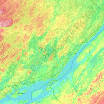
Nom : Carte topographique Silver Island, altitude, relief.
Altitude moyenne : 113 m
Altitude minimum : 72 m
Altitude maximum : 210 m
Autres cartes topographiques
Cliquez sur une carte pour visualiser sa topographie, son altitude et son relief.
Leeds
Canada > Ontario > Leeds and the Thousand Islands
Leeds, Leeds and the Thousand Islands, Leeds and Grenville Counties, Eastern Ontario, Ontario, Canada
Altitude moyenne : 104 m
Leeds and the Thousand Islands
Canada > Ontario > Leeds and the Thousand Islands
Leeds and the Thousand Islands, Leeds and Grenville Counties, Ontario, Canada
Altitude moyenne : 102 m