
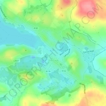
Carte topographique Shercock
Carte interactive
Cliquez sur la carte pour afficher l’altitude.
À propos de cette carte
Nom : Carte topographique Shercock, altitude, relief.
Altitude moyenne : 117 m
Altitude minimum : 85 m
Altitude maximum : 176 m
The region is known as "Drumlin Country" owing to its topography of small hills and lakes formed at the end of the last ice age. County Cavan borders County Fermanagh and County Monaghan. Together, they form the colloquially named "Drumlin County". Shercock lies on the border between County Cavan and County Monaghan.
Autres cartes topographiques
Cliquez sur une carte pour visualiser sa topographie, son altitude et son relief.
Kilnaleck
Kilnaleck, Ballyjamesduff Municipal District, County Cavan, A82 X567, Ireland
Altitude moyenne : 114 m
Callanagh Lower
Callanagh Lower, Drumlumman ED, Ballyjamesduff Municipal District, County Cavan, Ulster, Ireland
Altitude moyenne : 85 m
Virginia
Virginia, Virginia ED, Ballyjamesduff Municipal District, County Cavan, Ireland
Altitude moyenne : 98 m
Crossdoney
Crossdoney, Ballyjamesduff Municipal District, County Cavan, H12 K727, Ireland
Altitude moyenne : 67 m
Bailieborough
Bailieborough, Bailieborough ED, Bailieborough-Cootehill Municipal District, County Cavan, A82 NX86, Ireland
Altitude moyenne : 162 m
Mount Nugent
Mount Nugent, Ballyjamesduff Municipal District, County Cavan, Ulster, Ireland
Altitude moyenne : 74 m
Ballyjamesduff
Ballyjamesduff, Ballyjamesduff Municipal District, County Cavan, Ulster, A82 CT95, Ireland
Altitude moyenne : 118 m
Ballyconnell
Ballyconnell, Ballyconnell ED, Cavan-Belturbet Municipal District, County Cavan, Ulster, H14 EC99, Ireland
Altitude moyenne : 68 m
Cootehill
Cootehill, Bailieborough-Cootehill Municipal District, County Cavan, Ulster, Ireland
Altitude moyenne : 89 m
Cornafean
Cornafean, Ballyjamesduff Municipal District, County Cavan, Ulster, Ireland
Altitude moyenne : 82 m
Killashandra
Killashandra, Killashandra ED, Cavan-Belturbet Municipal District, County Cavan, Ulster, Ireland
Altitude moyenne : 62 m
Loch Gowna (Scrabby)
Loch Gowna (Scrabby), Scrabby ED, Ballyjamesduff Municipal District, County Cavan, Ulster, Ireland
Altitude moyenne : 80 m
Snugborough
Snugborough, Ballyconnell ED, Cavan-Belturbet Municipal District, County Cavan, Ulster, Ireland
Altitude moyenne : 174 m
Tullycoe
Tullycoe, Larah North ED, Bailieborough-Cootehill Municipal District, County Cavan, Ulster, Ireland
Altitude moyenne : 96 m
Togher or Danesfort Demesne
Togher or Danesfort Demesne, Killykeen ED, Cavan-Belturbet Municipal District, County Cavan, Ulster, Ireland
Altitude moyenne : 64 m
Corfad
Corfad, Stradone ED, Bailieborough-Cootehill Municipal District, County Cavan, Ireland
Altitude moyenne : 130 m
Lisdaran
Lisdaran, Cavan Rural ED, Cavan-Belturbet Municipal District, County Cavan, Ulster, Ireland
Altitude moyenne : 73 m
Cormeen
Cormeen, Larah South ED, Bailieborough-Cootehill Municipal District, County Cavan, Ulster, Ireland
Altitude moyenne : 133 m
Monaghanoose
Monaghanoose, Drumanespick ED, Bailieborough-Cootehill Municipal District, County Cavan, Ireland
Altitude moyenne : 140 m
Bailieborough
Bailieborough, Bailieborough-Cootehill Municipal District, County Cavan, Ulster, A82 NX86, Ireland
Altitude moyenne : 163 m
Cleffin
Cleffin, Killinkere ED, Bailieborough-Cootehill Municipal District, County Cavan, Ulster, Ireland
Altitude moyenne : 128 m
Bailieborough
Ireland > County Cavan > Bailieborough
Bailieborough, Bailieborough-Cootehill Municipal District, County Cavan, A82 NX86, Ireland
Altitude moyenne : 169 m
Seefin
Seefin, Drumanespick ED, Bailieborough-Cootehill Municipal District, County Cavan, Ireland
Altitude moyenne : 194 m
Kilnavert
Kilnavert, Ballymagauran ED, Cavan-Belturbet Municipal District, County Cavan, Ireland
Altitude moyenne : 68 m
Killaghaduff
Killaghaduff, Swanlinbar ED, Cavan-Belturbet Municipal District, County Cavan, Ireland
Altitude moyenne : 91 m
Drumgart
Drumgart, Ardue ED, Cavan-Belturbet Municipal District, County Cavan, Ireland
Altitude moyenne : 55 m
Cornamucklagh
Ireland > County Cavan > Cornamucklagh
Cornamucklagh, Crossdoney ED, Ballyjamesduff Municipal District, County Cavan, H12K727, Ireland
Altitude moyenne : 61 m
Bailieborough-Cootehill Municipal District
Bailieborough-Cootehill Municipal District, County Cavan, Ulster, Ireland
Altitude moyenne : 122 m
Carrickallen
Carrickallen, Larah North ED, Bailieborough-Cootehill Municipal District, County Cavan, Ireland
Altitude moyenne : 185 m
Dunaree
Dunaree, Kingscourt ED, Bailieborough-Cootehill Municipal District, County Cavan, Ireland
Altitude moyenne : 115 m
Laraweehan
Laraweehan, Knappagh ED, Bailieborough-Cootehill Municipal District, County Cavan, Ireland
Altitude moyenne : 104 m
Drumlane
Drumlane, Drung ED, Bailieborough-Cootehill Municipal District, County Cavan, Ireland
Altitude moyenne : 93 m
Cavan-Belturbet Municipal District
Cavan-Belturbet Municipal District, County Cavan, Ulster, Ireland
Altitude moyenne : 111 m
Glangevlin
Glangevlin, Cavan-Belturbet Municipal District, County Cavan, Ulster, Ireland
Altitude moyenne : 185 m
Kilcogy
Kilcogy, Ballyjamesduff Municipal District, County Cavan, Ulster, Ireland
Altitude moyenne : 89 m