
Carte topographique Saratoga County
Carte interactive
Cliquez sur la carte pour afficher l’altitude.
À propos de cette carte
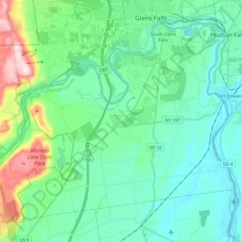
Nom : Carte topographique Saratoga County, altitude, relief.
Lieu : Moreau, Saratoga County, New York, USA (43.19942 -73.76352 43.30709 -73.58128)
Altitude moyenne : 116 m
Altitude minimum : 30 m
Altitude maximum : 442 m
Autres cartes topographiques
Cliquez sur une carte pour visualiser sa topographie, son altitude et son relief.
Avalanche Lake
Avalanche Lake, Avalanche Pass Trail, Essex County, New York, USA
Altitude moyenne : 1 066 m
Spike Island
Spike Island, Rye, Westchester County, New York, 10587, USA
Altitude moyenne : 50 m
Joshua
USA > New York > Town of Onondaga > Joshua
Joshua, Town of Onondaga, Onondaga County, New York, 13110, USA
Altitude moyenne : 332 m
Atlantic Basin
Atlantic Basin, New York County, New York, 11231, USA
Altitude moyenne : 4 m
Livingston Island
Livingston Island, Town of Philipstown, Putnam County, New York, 10922, USA
Altitude moyenne : 156 m
Big Bear Mountain
Big Bear Mountain, Town of Johnsburg, Warren County, New York, USA
Altitude moyenne : 616 m
Sawtooth Mountains
Sawtooth Mountains, Franklin County, New York, USA
Altitude moyenne : 927 m
Flat Top Mountain
Flat Top Mountain, Franklin County, New York, USA
Altitude moyenne : 568 m
Mount Warren
Mount Warren, Town of Bovina, Delaware County, New York, USA
Altitude moyenne : 677 m
Roosevelt Island
USA > New York > New York City
Roosevelt Island, Manhattan Community Board 8, New York County, New York City, New York, 10044, USA
Altitude moyenne : 13 m