
Carte topographique Alcona County
Carte interactive
Cliquez sur la carte pour afficher l’altitude.
À propos de cette carte
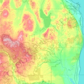
Nom : Carte topographique Alcona County, altitude, relief.
Lieu : Alcona County, Michigan, USA (44.50880 -83.88924 44.85953 -83.26956)
Altitude moyenne : 249 m
Altitude minimum : 172 m
Altitude maximum : 384 m
Autres cartes topographiques
Cliquez sur une carte pour visualiser sa topographie, son altitude et son relief.
Pine Grove Beach
USA > Michigan > Pine Grove Beach
Pine Grove Beach, Lake County, Michigan, 49394, USA
Altitude moyenne : 257 m
St. Clair River
St. Clair River, Saint Clair County, Michigan, 48054-1596, USA
Altitude moyenne : 191 m
Lake Esau
USA > Michigan > Presque Isle
Lake Esau, Boat Launch, Presque Isle, Presque Isle County, Michigan, 49777, USA
Altitude moyenne : 181 m
Hooker Lake
Hooker Lake, Rainbow Camp Road, Benzie County, Michigan, 49650, USA
Altitude moyenne : 252 m
Isle Royale National Park
Isle Royale National Park, Greenstone Ridge Trail, Houghton Township, Keweenaw County, Michigan, USA
Altitude moyenne : 189 m
Lake Mason
Lake Mason, Indian Portage Trail, Houghton Township, Keweenaw County, Michigan, USA
Altitude moyenne : 201 m
Lake Stella
Lake Stella, Pioneer Road, Alger County, Michigan, USA
Altitude moyenne : 244 m
Groveland Township
USA > Michigan > Groveland Township
Groveland Township, Oakland County, Michigan, USA
Altitude moyenne : 305 m